It’s been raining almost non-stop since we arrived here in Angaston. The skies opened up about a month before we arrived and rain has been pouring down ever since. Sunny days have been few and far between.
Although it’s been no more than a soggy annoyance here in the Barossa Valley, the same cannot be said for the rest of the country. Australia’s east coast is being devastated by massive flooding. Entire communities in the central outback have been cut off by historically high waters.
Unlike the rapidly moving bush fires Australia is known for, this is a natural disaster that occurs in slow motion. The most populous regions of the country are already flooded, but the recent rains in the outback have only just begun rolling slowly down Australia’s sluggish rivers and will not crest in those areas for another six weeks. And yet the rain continues pouring down.
Here’s a news story to explain some of the devastation that’s already been caused by the flooding. And remember, the worst is not expected for another month and a half.
In 1956, heavy rainfall led to the historic flooding of the River Murray. It caused widespread damage and is still considered South Australia’s greatest natural disaster.
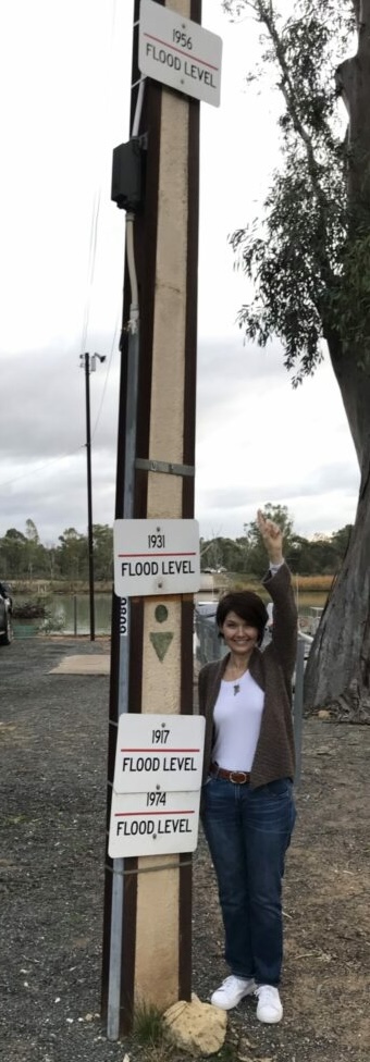
The photo below was taken three years ago along the Murray in Swan Reach, just 37 miles east of Angaston. Clearly, the infamous Flood of ’56 was one for the record books. Jamie’s standing at a spot that’s probably twenty feet above the level of the river, yet the sign shows that the river rose not just to where she’s standing but another ten feet higher during the worst of the flooding.

The Murray is Australia’s longest river. It’s 1550 miles (2508 kilometers) long, and flows through the states of New South Wales, Victoria and South Australia. Almost 1200 miles are navigable, making it the third longest navigable river on the planet. Only the Amazon and Nile rivers are longer.
That being said, let’s not get carried away in comparisons to the Amazon and Nile because the River Murray really isn’t much more than a very long creek.
Its average discharge is a mere 27,100 cubic feet per second. The Nile’s average discharge is 99,940 cubic feet per second and the Amazon’s is a remarkable 7,380,765 cubic feet per second. In other words, more than 750 times as much water flows into the ocean from the Amazon than from the Murray.
At 1550 miles, the Murray’s length would rank fourth or fifth among American rivers. However, it would rank only 30th in volume, right between the Kootenia and Pend Oreille Rivers, which are both tributaries of the Columbia River and are probably unknown to anyone outside America’s Pacific Northwest.
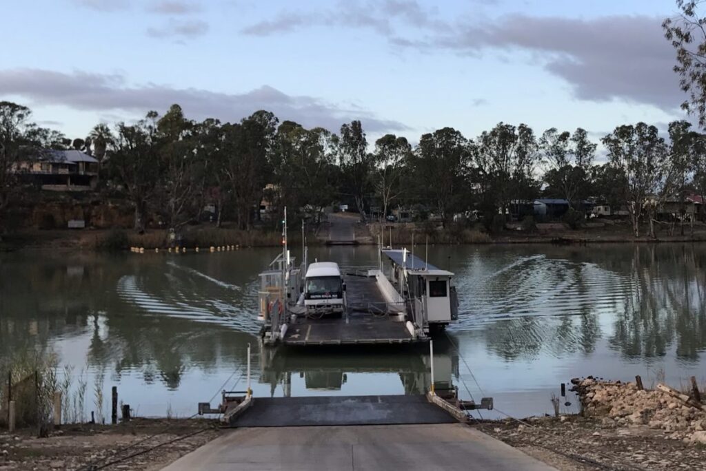
We took this photo of the Murray three years ago about 100 feet north of the spot where Jamie was pointing up to the flood level sign. This is what the river looks like during a normal rainy season. It’s so narrow that the ferry crosses from one bank to the other in about 30 seconds.

According to American folklore, George Washington threw a dollar across the Potomac. Thanks to inflation, the dollar doesn’t go as far as it used to, and Washington’s arm ain’t what it used to be, so that probably wouldn’t be possible today. But the River Murray is so narrow that even wizened up ol’ Joe Biden could probably wind up and toss an Aussie dollar from one bank to the other. Unfortunately, he wouldn’t remember why he did it and would then veer inexplicably into telling some rambling, pointless, unrelated story until Jill approached the podium, took his hand, and led him back to the basement for another dose of Adderall and a Botox booster shot.
I beg your pardon. My apologies. I just did a bit of a Biden there myself, but unlike Sleepy Joe I am still able to correct course and get back on subject.
Unfortunately, this is just the nature of land and water in Australia. Years of torrential downpours and devastating floods always put emphatic exclamation points at the end of years of drought. It’s been like this for millions of years.
Nevertheless, Tim Flannery, Australia’s official Chief Climate Commissioner (and unofficial Chief Climate Hysteric) is one of those global warming scaremongers who keep getting quoted in the media even though he’s been wrong — embarrassingly wrong — with every one of his predictions for decades.

“I think there is a fair chance,” he frighteningly opined back in 2002, ”Perth will be the 21st century’s first ghost metropolis.” Luckily, Western Australia’s rains and reservoirs have persistently refused to cooperate with Flannery’s wild-assed scare quotes prognostications. It’s also been discovered that Perth sits atop a underground aquifer that holds a 500-year supply of water. (If we lived in Perth and Jamie watered our yard like she does in Texas, that supply would quickly be reduced to about 18 months.)
Flannery should have stopped while he was only slightly behind, but in 2005 he doubled down by saying:
But since 1998 particularly, we’ve seen just drought, drought, drought, and particularly regions like Sydney and the Warragamba catchment – if you look at the Warragamba catchment figures, since ‘98, the water has been in virtual freefall, and they’ve got about two years of supply left, but something will need to change in order to see the catchment start accumulating water again…. So when the models start confirming what you’re observing on the ground, then there’s some fairly strong basis for believing that we’re understanding what’s causing these weather shifts and these rainfall declines, and they do seem to be of a permanent nature… Well, the worst-case scenario for Sydney is that the climate that’s existed for the last seven years continues for another two years. In that case, Sydney will be facing extreme difficulties with water.
In 2007, the climate expert alarmist once again opened his mouth and inserted his foot when he said:
So even the rain that falls isn’t actually going to fill our dams and our river systems, and that’s a real worry for the people in the bush.
2007 was a particulary bad year for Flannery. He also issued this outlandish prediction:
Over the past 50 years southern Australia has lost about 20 per cent of its rainfall, and one cause is almost certainly global warming. Similar losses have been experienced in eastern Australia, and although the science is less certain it is probable that global warming is behind these losses too. But by far the most dangerous trend is the decline in the flow of Australian rivers: it has fallen by around 70 per cent in recent decades, so dams no longer fill even when it does rain … In Adelaide, Sydney and Brisbane, water supplies are so low they need desalinated water urgently, possibly in as little as 18 months.
Sydney’s dams have been full to overflowing since Flannery issued the first of his awkwardly inaccurate predictions. One year, in fact, there was so much rain that the reservoirs couldn’t hold it all. In an effort to keep the dams from bursting, authorities were forced to release vast volumes of water which resulted in massive flooding downstream.
And now we have this year’s horrible, destructive flooding. I think I would be far more accurate than Flannery if I were to predict that he will continue making bad predictions.
One might even say that much like Australia’s dams in a rainy year, Flannery’s predictions just don’t hold water.
Hi Jim
A little bit of info for you. I witnessed the 1956 floods at Mannum.
More info. Elizabeth’s dad Bruce Fitch built a 1 car ferry and installed it at Blanchetown during the 1956 floods. The river level was so high that the Government run ferry at Blanchetown was unable to be used. He built this ferry to enable farmers to send their crops from the other side of the river to markets in Adelaide & also so that the local people could access the town.
Really interesting. That flood must have been remarkable to witness.
We live here and it totally blows my mind to even begin to understand that the river got that high and wide and inundated that many towns. And no technology and machinery like there is now to cope with flooding. There is also a mark on one of the hotels verandah post in Mannum showing the 56 level and it’s so high above the “normal” river level it’s hard to believe